Woodbury Historic District Number 2
LHD boundaries as described are approximate and subject to change. Consult the LHD Study Report on file with the relevant local district commission or municipal authority to verify district boundaries and whether a specific property, particularly one in proximity of a boundary line, is within the district. Also note that LHD boundaries may differ from those of State or National Register Districts.
- Town:
- Woodbury
- Year of Establishment:
- 1968
- District Authority:
- Historic District Commission, Woodbury
- Link to Commission or Municipal Website:
- Map:
-
Map of the historic district retrieved from the Historic District Study Committee, 1969, SHPO Library, Hartford.
View photo - District Character:
- Rural neighborhood
- Features:
- Architectural Style:
Colonial, Federal, Greek Revival
- Era:
- 18th Century, 19th Century, 20th Century
Buildings
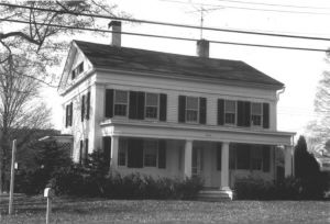
The Woodbury Historic District No. 2 is a residential area, bounded by open fields and woods. Its southern boundary line is the town line of Woodbury and Southbury, where the Southbury Historic District begins, creating an unbroken stretch of three miles along U.S. Route 6 where houses built before 1828 predominate. Some of Woodbury's finest old homes lie in the one-mile district between the town line and the commercial area, the district's northern boundary. [NR]
Architecture, Military: The Woodbury Historic District No. 2 is a continuation of Southbury's Historic District and extends north to the commercial area, beyond which lies Woodbury Historic District No. 1. The second Historic District is important because its architecture and historic sites embody the history of the area since the seventeenth century.Woodbury was an active participant in the Revolutionary War. Miss Crofut states that at least half of Ethan Allen's men at Fort Ticonderoga were natives or residents of the town. It is said that the town contributed nearly 1,500 men and half a million dollars' worth of supplies. Since Woodbury was on an inland, protected route, French troops marched through, from Boston to Yorktown in June, 1781, and again in October, 1782, on their return to Boston. In 1778 General Washington sent his troops to build a bridge across the Housatonic River, between Newtown and Woodbury; this area is now part of Southbury. In all probability Washington passed through Woodbury on his fourth journey through Connecticut in September, 1780. Woodbury Historic District No. 2 is important to the Town of Woodbury to preserve the heritage and beauty of the area. [NR]
[1] District information retrieved from the town website http://www.woodburyct.org/.[2] North District and South District, Woodbury, Report of the Historic District Study Committee, 1969, SHPO Library, Hartford. [3] Woodbury Historic District Commission Regulations, accessed from the website http://ahhowland.com/regulations/litchfield-county/Woodbury/historic-district/historic-district-regulations-1-16-03.pdf.[4] Assessors information and Parcel IDs retrieved from the website http://www.cogcnvgis.com/Woodbury/AGS_MAP/.[NR] Babbitt Susan, Woodbury Historic District Number #2, National Register Nomination Number- 72001326 NRIS, National Park Service, 1971 - http://pdfhost.focus.nps.gov/docs/NRHP/Text/72001326.pdf; http://pdfhost.focus.nps.gov/docs/NRHP/Photos/72001326.pdf
The north and the south boundaries of the district are not are closed in the district map attached with the Historic District Study Committee Report, 1969, SHPO Library. Although it is not categorically mentioned in the National Register nomination, the local historic district and the National Register historic district appear to be co-terminous.
- Date of Compilation:
- 11/15/11
- Compiler:
- Manjusha Patnaik, CT Trust for Historic Preservation